Please observe these signs as disreguarding them will be fuel for them to have us removed from this area, and to have it possibly fenced off forever, and use your common sence about treading lightly.
This is a lot of fun and very interesting, so let's keep it open for all of us to enjoy over and over again.
Thanx, Jeff -
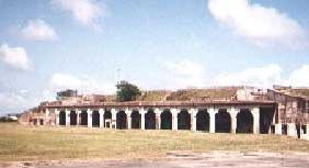
This is also a great trip to see the old millitary installment (Fort Travis) on Boliver point as well as the Boliver light house (as many of you know I collect them).
We will also be riding the ferry from Galveston to Boliver, this means, we arrive on friday, see the sites and wheel out and camp overnight, then wheel on to Sabine Pass and then half way back to camp again before we finally wheel out take the ferry back and head home.
Anyone interested????

Photos taken 7-September-2001
Western End at High Island
Although the road is closed, the beach is still open to vehicles. There was a surprisingly large number of vehicles cruising along the beach at the end of the road. Since beaches to the west are very popular, there is a certain amount of overflow to this section.

Eastbound motorists on Texas 87 are diverted northward on Texas 124 at High Island. Although not visible in this photo, High Island is on a tall salt dome. Its thirty-eight-foot rise above sea level makes High Island the highest point on the Gulf of Mexico between Mobile, Alabama, and the Yucatán Peninsula. There are plenty of stripper oil wells around the Salt Dome.


There is plenty of evidence of the former road along the beach. This view shows a debris field of asphalt chunks.

This is the most dramatic evidence of the destroyed road.

A jeep maneuvers around the big asphalt chunk in the middle of the beach. Because of the asphalt strewn all along the beach, it's a good idea to have a truck or high-riding vehicle (preferably 4 wheel drive) when driving along this section of beach.
East End, at Sabine Pass
Texas 87 near Sabine Pass is very desolate and isolated. This isolation is one of the main reasons why local authorities have been trying to get the highway rebuilt:


The road comes to an abrupt end. Foliage has taken over the broken up asphalt just ahead. It's interesting how the roadway end is so different on the east and west ends. Perhaps the heavy traffic on the west end has prevented the growth of foliage on the west end.


First-hand report of driving the lost highway route
On September 29, 2003, I received a report from a TexasFreeway.com reader who drove the full length of the washed out highway. His report details a fascinating driving adventure. It sounds like conditions are very challenging and the route is becoming increasingly difficult to traverse. He called his journey transcendental. For me, the scenes of my 2001 visit (particularly at the east end) were surrealistic and are permanently etched in my memory. The road pavement came to a halt and natural vegation was ahead. Thunderstorms were forming in the distance. Waves were crashing.
Awhile ago I was doing some research on Texas 87 between High Island and Sabine Pass and came across your TexasFreeway website. I loved the pictures and mystery that the photos left me with, so I decided that I was going to conquer it.
I took my girlfriend in my 2000 Ford Ranger 4x4 and waited for a nice, dry day and until low tide to proceed. Needless to say, it was an awesome adventure. Once I got past the crazy nude beaches (I had no idea that there were any in Texas), we were alone. It was quite scary, and the conditions were awful. There was no road or roadbed...just marsh to drive upon. The only low point was when the marsh was unable to be passed due to extremely deep mud (> 12"). I had to get out and build my own road using pieces of the road that remained. Numerous, cavernous bumps (thankfully, my truck has the 18" ground clearance) coupled with deep mud made it quite a jarring ordeal.
We had to navigate through a series of fences put up by the gov't, which required much maneuvering. I had to use 4x4 Low the whole way, as it was quite muddy and bumpy. After passing three abandoned oil processing centers (2 hours later..quite possibly the longest it's ever taken me to drive 20 miles), we made it to Sea Rim State Park (which I suppose is the reward for completing the route, as we got in free). Hundreds of beautiful, gigantic pelicans gracing the sky was quite a transcendental experience. I just wanted to say thank you for inspiring me to undertake the most challenging experience of my life, as well as the most rewarding one in my short 23 years.
Here some links of possible intrest for the trip:
Fort Travis:

Bolivar Light House:

Galveston Ferry

Nope sorry folks this won't like a huge rock crawling, highly technical trail run, but what I see is a great historical getaway with the real live living show of how nature changes the earth.
This is calculated to be a 3 day 2 night trip starting on a friday meet-up (On Galveston Island) and ending Sunday.
Mainly all you will need is fuel (don't foget extra(Jerry Cans)) and food/water, plus the accomodating gear to get you through the night.
There is no people, stores, perse' roads, buildings, nothing for 20 miles, so be prepared, also huge camp fires are a go, as we'll collect wood along the jouney.
As for towrigs (if you plan to tow your rig), you can look at the camping cost for Fort Travis and leave them there for the weekend.

